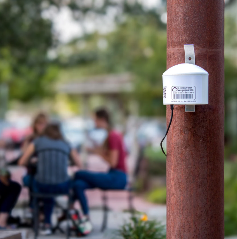
In Spring of 2026, Williamstown Health Department will install five air quality sensors around town. These sensors, called PurpleAir Flex sensors, let anyone check local air quality online, in near real time. The Town received these sensors for free through the Massachusetts Air Sensor Grant Program administered by the Massachusetts Department of Environmental Protection.
Air quality sensors tell us how clean or polluted the air is. The PurpleAir sensors measure airborne particulate matter – tiny particles from sources such as smoke, dust, and other pollutants that can affect your breathing and health. The sensors use laser particle counters to estimate concentrations of particulate matter (PM1, PM2.5, and PM10) and send their readings to a public online map that anyone can view. In addition to the five sensors in town, you’ll see a sixth sensor on the map, installed by Williams College in Hopkins Forest.
Community air sensors are a helpful tool for tracking air quality throughout the day, especially during events like wildfire smoke and dry, dusty weather. The sensors reveal localized pollution patterns that traditional networks, like the U.S. Environmental Protection Agency (EPA), can miss. While they are not used for official regulatory purposes, they give residents and town staff useful information about local air conditions.
Williamstown also expects to benefit from the Berkshire County Clean Air Project, a regional initiative led by the Berkshire Regional Planning Commission (BRPC) with EPA funding, which will install four additional sensors in town. Check back here for updates on accessing that data as it becomes available.
Check Local Air Quality Online
- PurpleAir Map-Williamstown – See live readings from Williamstown sensors and nearby areas.
- AirNow Fire and Smoke Map – Track wildfire smoke and related air quality impacts in the region.
Free Mobile Apps and Alerts
- AirNow App – Check current and forecasted Air Quality Index (AQI) for your location or any area in the U.S. Includes the EPA/U.S. Forest Service Fire and Smoke Map, plus monitoring data for PM2.5, PM10, and ozone — including readings from PurpleAir sensors.
- IQAir Air Visual Platform – See air quality data from PurpleAir sensors and EPA monitoring stations. Features customizable alerts when air quality deteriorates, daily notifications to help plan outdoor activities, and threshold-based warnings.
- EnviroFlash – Sign up to get email alerts when local air quality reaches a level that could affect your health. Note: EnviroFlash uses data from government monitoring stations, not PurpleAir sensors.